|
|
Ordnance Survey Maps of
Scotland
The most useful of the Ordnance Survey
(O.S.) maps for the fisherman is the Landranger series, scale
1:50,000. For each of the lochs and rivers listed in these pages, I have given the
relevant O.S. Map number. In addition to the information
provided on this website, I would recommend that anyone planning a fishing or walking trip
in Scotland should equip themselves with a compass and the appropriate Ordnance
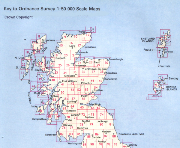
Survey map.The map below shows the areas of
Scotland covered by the various O.S. Maps and the map numbers of the relevant
Landranger Map, as published by the Ordnance Survey.
See also Maps of Scotland
for detailed reduced survey maps covering the whole of Scotland, relating
particularly to the fishing lochs and rivers of Scotland.
Reduced ordnance survey maps, on a scale of half inch to one
mile, were produced throughout the twentieth century by John
Bartholomew & Son of Edinburgh. They were very popular for
those engaging in outdoor recreational pursuits such as
cycling, touring, walking and fishing.
So you have your map, your compass, your walking boots
and midgie repellent. Where will you fish? For a
comprehensive guide to fishing on the lochs and rivers of
Scotland, I would recommend that you invest in a copy of
Bruce Sandison's excellent book:
Rivers & Lochs of Scotland: The Angler's Complete Guide 2013/14
|
|
Ordnance Survey Map Numbering System
The Ordnance Survey Landranger map series, scale 1:50,000
(2cm to 1km or 1 1/4 inches to 1 mile), covers Great Britain
in 204 sheets and is suitable for detailed exploring by car
or on foot. Rights of way and over 100 types of
topographical detail are shown, including viewpoints,
footpaths, streams, woods, crags, contours, stately homes,
parking places, bus and coach stations, camping and caravan
sites and ancient monuments and buildings.
Ordnance Survey maps enable users to find or give the
location of places by means of the Grid Reference System,
which is explained on each map.
|
|
|